
The Best Navigation Aid Amidst The Action
Designed for Small Boats
Between the waves, the gusts, and everything else on board, being in the action can be all-consuming. MAPTATTOO was designed to give you the easiest experience navigating – so you can focus on what truly matters. With its E-Ink Screen, readable in sunlight, usable with wet fingers, and with exceptional battery life, it is the navigation aid for your next adventure.

Readable in Direct Sunlight

Excels in a Wet environment

50-hour Battery life
Readable in Sunlight
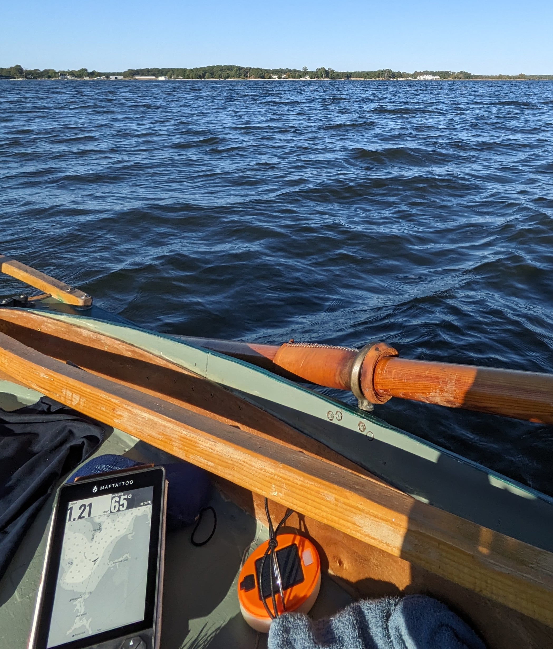
Sunlight readability is critical when navigating outside. The large 6″ E-Ink touchscreen makes our chartplotter perfectly visible in any condition and at any angle, giving you an edge in your next race and allowing you to fully focus on your boat.

“Even when my phone was at full brightness with the glare I couldn’t see anything on the screen effectively rendering it useless, but I could easily see the screen of the MAPTATTOO”
– Enzo Dougherty, rower, Seventy48 participant


Exceptional Battery Life
MAPTATTOO chartplotter’s battery lasts for 50 hours. We optimized the battery life to keep it extremely low-power consuming so you can navigate with confidence, no matter how long the journey is.

“MAPTATTOO is already an indispensable tool onboard. During a one week raid, we used it every day, and only neeeded to charge it once. It still has 40% battery.”
– François Frisch, sailor, Trimaran MOD 24 skipper.
Join the Explorers Team
Stay up to date with our next updates and subscribe to our newsletter now!
Use With Wet Fingers
Rugged and waterproof, MAPTATTOO touchscreen is designed to excel in wet environment and can be used with wet fingers. But when conditions get really tricky, you can always rely on the tablet’s keypad.

“This is a very good product released by fellow R2AK and Watertribe sailors. It fulfills the needs of waterproof functional tablet, designed just for the purpose of navigation of a small boat in wet environment.”
– Vladimir Eremev, sailor, Everglades Challenge and R2AK racer


Navigate With Confidence
Built by sailors, for sailors. We designed MAPTATTOO’s hardware and software from the ground-up, optimizing the form and function to be the best they could be.
- Large 6″ E-Ink Screen
- Easy to mount
- No installation needed
- Fast USB-C charging
- IP68 Waterproof
- Free Firmware and software upgrades
- 1-year warranty, free returns

GPS Nautical Charts: USA, Canada & France
USA Pacific | USA Atlantic | USA Great Lakes | USA Inland Lakes | Canada Pacific | Canada Atlantic Canada Great Lakes | Canada Inland Lakes | Canada Arctic | France
Coming soon: UK, Ireland
See The Difference
We fixed the flaws of most boat navigation solutions. Here’s a breakdown.

MAPTATTOO |

SMARTPHONE |

HANDHELD |

CHARTPLOTTER |
|
| 6″ Screen |  |
 |
 |
|
| High Visibility Numbers | |
|
|
|
| Touch Screen | |
|
|
|
| Works with wet fingers | |
|
|
|
| Visible in direct sunlight | |
|
|
|
| 50-hour battery life | |
|
|
|
| Rugged construction | |
|
|
|
| IP68 Waterproof | |
|
|
|
| Portable | |
|
|
|
Our customers share insights

Knocking off one star for the following issues:
- The battery gauge was faulty when I received the device, and I was also unable to connect it to my computer to upload waypoints or charts. Support was responsive and they ultimately repaired the issues under warranty, but still, it's not what I expect from a brand new device at this price point. I was without it for a few weeks during shipping and repair.
- Using the touch screen to select waypoints and other items on the map is buggy (presses usually either don't register or they register as map pans). Support was once again responsive and they said they have a fix coming with the next software update.
- There is no way to select existing waypoints from the map when creating a route. You either have to place new waypoints or search for existing waypoints by name.
So in spite of my own extensive yachting experience and the fact that our Grand Banks Has both a Raymarine program and a computer running Coastal Explorer, I have found the Maptatoo to be extremely helpful and easy to use. Two of its obvious strong points are it's readability and its portability. In short, I have found the Maptatoo to be a great addition to our already complete (or so we thought) navigation ensemble.
The display is consistently clear. I use a Quad Lock mount on my deck, which effectively replaces a plastic map case and eliminates the need to cut and size oversized paper charts for multi‑week trips. The operating system is simple and the battery life is excellent. I still carry printed charts as a backup.
When I pause paddling during a crossing, the tide current vector appears immediately, allowing me to adjust my heading in real time.
The heads‑up chart plotting greatly simplifies piloting and navigation through shoals, island groups, and dense fog.
I can confidently bear toward preloaded campsites without hesitation or the need to consult a phone or handheld GPS.
It’s rugged, intuitive to operate, and refreshingly simple.
Many thanks to the designer for creating a tool so well suited to real-world coastal kayaking.
This is an exceptional piece of gear, it fits my needs better than any other navigator I have used. I recently had the opportunity to use it on my kayak sailboat navigating and camping in the Ten Thousand Islands out of Naples, FL.
The good:
It is crystal clear in low light and direct sun. The images are crisp, with fine detail. The maps are beautiful and surprisingly detailed, and the screen size makes all this detail actually useful. The search function works amazingly well, there was nothing I asked for that the device could not locate.
Navigating was a pure pleasure. I mostly used point-to-waypoint but I also had a chance to create and follow routes. For this function the device is far superior (smarter) compared to my Garmin 86sci. And the touch screen makes selecting a waypoint so much easier than the Garmin. And as far as visibility, well, the two devices just don’t compare. Other than that the Maptattoo has all the functions that I need, with the exception of a couple of nit picky items that are just personal preferences.
I love the ability to superimpose current data on the map, this is so much easier than toggling between map and data views. That said I actually would prefer to have the data displayed until I want to hide it, but the device turns the data off after a minute or so (is that to save power?). It is easy enough to call it back up, but I really like having it displayed longer on the map. Everything I need is there for tracking progress and estimating arrival, it calculates everything in a useful and intuitive way. But is there any way to show estimated arrival TOD at destination? Oh, and can it switch from 24 hour to 12 hour clock? While we are on the display, the only suggestion I have is to make the track line bolder/easier to see. It is OK, but bolder would be better for me for both the navigating line and the track. Also, while the course deviation (shown in degrees on the info display) is really helpful I would personally also like to have velocity made good as an option, but no big deal.
All in all I could not be happier. This device is an uncompromising improvement and it has added significantly to my enjoyment of small boat navigation, thanks!
My boat has no way other than a small solar panel to charge the boat battery this ruled out a chart plotter like Raymarine. Maptattoo with its built in battery and 6" screen I feel that I have found a good fit. Now I am looking for a mount that will secure it so that it won't fall over board. The many lines and shifting side to side while tacking are my concern. A flush mount and a tiller extension my resolve this concern. Returning this spring I will use the training and be familiar with Maptattoo, I can have a less stressful adventure.
Sailing the Georgian bay and the North Channel. See you out there.
Walt

I have not used it on the boat due to weather but have set it up in my home as well as in a vehicle. All simulations seem flawless and accurate. I am very impressed with the battery life which seems to never run out. I have used it several hours at a time which is as long or longer than any race and the battery shows no usage. I would guess that the advertised life of 50 hours is right on or not far off. I have never had a battery last this long in such a small package.
I also like the idea that It can be mounted most anywhere with various mounts either purchased on the Maptatoo site or from outside sources. The Maptatoo company has been very helpful in suggesting other effective ways of mounting that does not need to be purchased from the company.
I would gladly purchase again. If on the fence, do yourself and favor and find the unbiased articles on its' actual use.
Would like to see... 1) Option to change the scale of the boat-arrow, soundings and buoys independently, and 2) Note buoys by their color/number and not by name (e.g. "R 5" vs "Hopkinton Shoals Buoy").
Would definitely recommend this product.
Hoping to see updated Small Craft Routes on Georgian Bay (AquaMaps?) available for next season as this area is not supported yet. Customer support has been excellent, all questions have been answered clearly and promptly.
Overall, I am very pleased with the unit.
I will be completely honest, I kept it in a soft, waterproof tablet case the whole time. It's not a reflection of the waterproofed quality of the device, but more a reflection that I don't trust any device to hold up to such prolonged wetness.
In the position it was in it was regularly under breaking waves, and I just wanted extra protection.
The battery this device has is phenomenal. I didn't have it powered on the whole time, but would power it on from time to time to check my location and my speed. Sometimes I would keep it on for hours at a time just so I could see my speed.
I did have a few instances where the screen would freeze when booting up, or the whole device would suddenly freeze up. In all instances I just turned the device off and on again to resolve.
I realized at one point that when trying to charge it from a battery pack with a USB-C connection that the battery pack was actually charging from the MapTattoo. I changed cords to a Type A to C style and was able to resolve. That's not really a mark against the device, but perhaps worth bearing in mind.
I wish it was possible to forgo the touch screen completely while still being able to access the tide and current information.
The details of the chart are a little imprecise when compared to the larger scale paper charts. As a kayaker I'd love for more information about the aggregate of the intertidal.
Overall it's a really good device. Perhaps not perfect for kayakers but a heck of a lot better than the other alternatives I've tried.
The first outing was a kayak tour to test basic functionality. It handled waypoints beautifully—automatically switching to the next waypoint when crossing the 90-degree threshold from the previous one. Very intuitive. Biggest takeaway from that trip: I missed the feedback from the device after switching to a different kayak.
Second trial was on a DIAM 24 in wet, spray-filled conditions. The standout feature here was the VMG (Velocity Made Good) calculation. On a boat that sails wide angles, it was incredibly useful to visualize the trade-off between speed and distance—really helped with tactical decision-making.
Feature request:
When actively sailing to a waypoint, the map view becomes less helpful since it’s often not within easy view of the helmsman. It would be great be able to switch to a simplified display option showing just the essentials:
• Speed
• Heading
• Distance to Target
• VMG
• Target Heading
• Degrees to Target
Basically, just the first two rows of data in a clear, compact view taking up the whole screen.
Overall: I love this device and would absolutely buy it again. Great tool.


I bought your unit because we now cruise about in boats 20’ and under, the 50-hour battery life is fantastic, the traditional-looking chart format feels like home to me, growing up continuously using charts, and my old school navigation background to get about. The screen can be seen in any light. Just great. Your unit is easy to use, I like the large numbers for speed because in a small vessel going 5 knts +- it’s nice to be able to use to see current changes quickly in passages up here. Being outside in the rain, being able to have your unit as my helper in navigation with no worries of battery time, wet chart or guide book, seeing real-time position and speed is the next level up of today's navigation tool.
Racing Accross the Everglades
Grueling and extreme, this sailing race is not for the faint of heart. Read Ryan Finn’s remarkable telling of the Everglade Challenge and his use of MAPTATTOO.
“Their navigation tablet, designed specifically for races such as the Everglades Challenge and Race to Alaska worked perfectly. The unit is waterproof, holds its charge for 50 hours and has a screen that is easily viewable in broad daylight. Maptattoo was 90% of my navigation during this event and the only thing powered on when I finished.”
